
Plymouth Neighbors by Block Source
Public sources describe a block in layers. Start with the city or county map to orient the address and adjoining parcels. Use PINS to confirm a parcel identifier and its property details. Historic directories can help place past households, but they are not current rosters. The voter lookup has a tightly controlled purpose and uses identity and address fields to confirm registration status. Association material may publish a board or contact without publishing every member.
| Source | What it shows about a block | Access |
|---|---|---|
| Plymouth ParcelViewer | Parcels, roads, building footprints, zoning, lakes, businesses, city limits | Official map-service route |
| Hennepin PINS | PID, situs and mailing fields, legal description, assessment and recording clues | Current parcel portal |
| Recorder research | Recorded instrument parties and legal-description trail | Online and Recorder access routes |
| MNVotes | A registration-status result for a lawful lookup | Controlled state route |
| Community pages | Published association identity or public board contact | First-party materials only |
Owner, taxpayer, map-adjacent parcel, association officer, and resident are not interchangeable labels. A map shows proximity. It does not prove a personal relationship or a current household.
Plymouth ParcelViewer Maps the Block
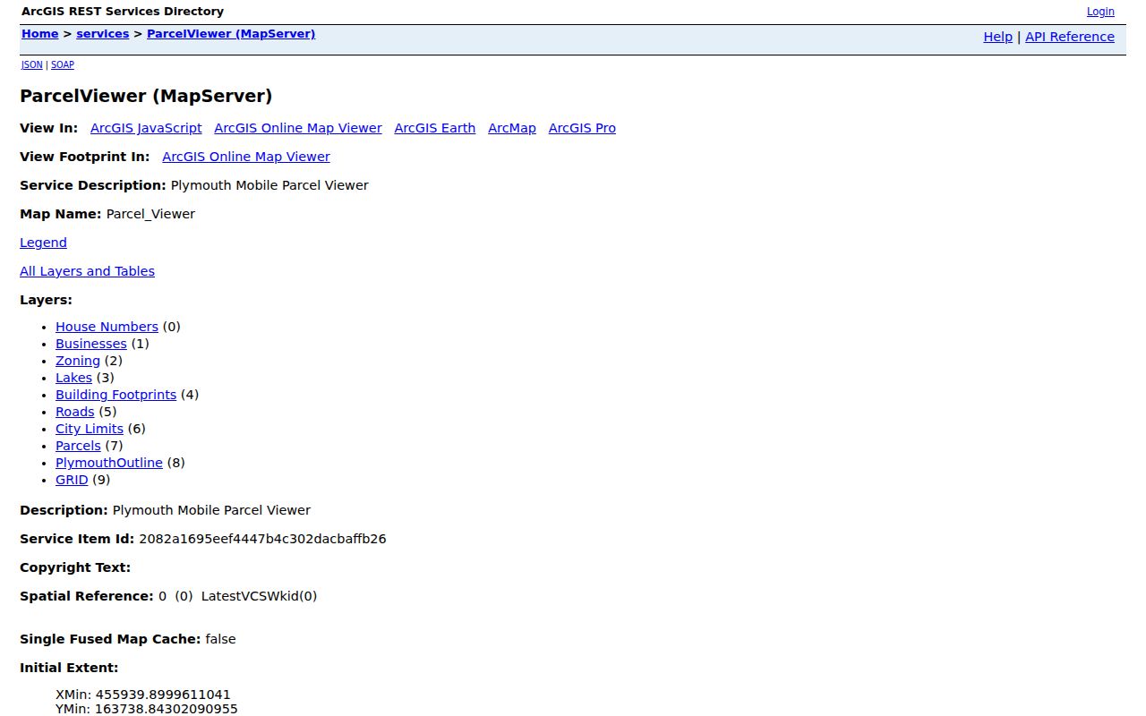
Plymouth ParcelViewer provides city-level layers for house numbers, businesses, zoning, lakes, building footprints, roads, city limits, parcels, the Plymouth outline, and a grid. Its service exposes Identify, Query, Find, and Export Map functions, plus map-data formats. The public research use is geographic orientation. It is not a friendly person-name directory, and it should not be treated as one.
Record the road, parcel shape, building footprint, lake or shoreline context, zoning district, and city-limit position. Then compare the parcel with the county record. The service describes a dynamic parcel feature class joined to city property data and has a maximum record count of 5,000. That technical capacity does not change the proper, small-scale use of the map for one block at a time.
The city layer service is shown in the source capture below.
Use a county parcel source to verify a boundary or property fact before recording it in a Plymouth neighbor note.
Map a Plymouth Block Step by Step
Start from one exact address and work outward only to adjoining parcels. The sequence keeps map geometry separate from ownership records and helps avoid a broad person search. If the goal grows into a full street history, use the Plymouth street directory workflow instead of treating a short radius as the whole street.
- Enter the printed address in PINS with house number and street name, and save the PID and legal description.
- Find the parcel in ParcelViewer and identify the directly adjoining parcel shapes, roads, and layers.
- Return to PINS for each parcel only when a specific property question requires it.
- Use Recorder research by legal description for a recorded transfer question, not to infer every occupant.
- Keep the source date, access route, and uncertainty next to each block observation.
A homestead indicator, when the county record identifies one, can be owner-occupancy evidence. It does not prove every person in a home. A tax mailing address is likewise not a reliable resident address.
Plymouth Neighbors Need Map Context
Plymouth's map layers are useful because they place a parcel within the city. Roads, lakes, zoning, building footprints, businesses, and city limits give a reader useful geographic context. They do not turn a nearby parcel into a household connection. Pair the current map with PINS for a parcel record, a plat or survey for legal boundaries, and the Recorder for recorded documents.
This geography also helps with records that use a subdivision or historic road term. County Road 47 became Chankahda Trail in 2022, so an older permit, newspaper, or directory search may require both names. Preserve the historic spelling as an alias. Do not replace it with the current label and lose the search trail.
Note: Parcel adjacency is a map fact; a neighbor relationship requires more than two lots touching on a screen.
Plymouth Community Contacts Are Limited
First-party association pages can explain a neighborhood's public identity without producing a residential roster. Fawn Creek Neighborhood Association lists community governance and board or committee contacts. Jamestown Village published a 2025 board and a general association contact. Kingswood Farm describes a 112-home townhome community near Gleason Lake, common property, and public contact information. Dates matter because volunteer board information changes.
| Community lead | Published public purpose | Use boundary |
|---|---|---|
| Fawn Creek | Association governance and contact route | Not a member directory |
| Jamestown Village | Association board/contact page | Board listing is date-specific |
| Kingswood Farm | Community amenities and association contact | Not proof of household membership |
Jamestown Village's public contact page is represented in this capture. Treat it as organizational information, not a resident list.
City Night to Unite encourages neighborhoods to update their own directories and hold block events. A private directory may exist, but that does not make it a public citywide resource.
Plymouth Voter Data Has Rules
Minnesota's voter registration lookup asks for first name, last name, date of birth, ZIP or county and city, house number, street, and a unit where needed. A successful result concerns registration status at the time searched. It is not a public neighbor list. A blank result can reflect spelling, processing, a changed address, a mismatch, or a protected classification.
Minnesota Statutes §201.091 distinguishes the master list from the public information list. The official voter-list request form offers geographic and report-format choices under statutory requester purposes and procedures. Do not use voter information to construct a profile of a block. Party selection is not a general public registration field.
Plymouth Official Records Versus Listings
Official parcel, recorder, court, and election sources identify their custody, record dates, and access limits. Commercial neighbor tools often mix dates and roles without making those differences clear. A parcel taxpayer can be different from a resident. A past directory occupant can be different from a current owner. An association contact can be different from both.
| Official record route | Commercial listing category | Practical check |
|---|---|---|
| Dated, named custodian, stated access rules | May combine sources with unclear refresh dates | Confirm with the original custodian |
| Specific record role and field | May label several roles as one person profile | Keep owner, occupant, and board role separate |
| Can show a stated boundary or legal source | May imply relationships from address proximity | Use map adjacency only as geographic context |
Plymouth Neighbors Have Privacy Limits
Safe at Home protects a participant's actual address. Confidential vital records, sealed and juvenile court material, private voter information, private police data, and nonpublic association membership remain protected. Minnesota's Data Practices Act starts with public access only where data has not been classified otherwise. A protected or absent record is not an invitation to triangulate what was withheld.
Plymouth's 2026 permitting-scam warning also shows why public property and permit context should be used carefully. Verify an official-looking request through the city's published contact route, not through a message sender. Keep personal research focused on civic, property, neighborhood, or family-history questions. Record the source date and what the source actually classifies as public before sharing a research note with anyone else.
Lawful use. Plymouth neighbor research can support local history, civic awareness, property curiosity, and reconnecting through lawful sources. Do not use it to stalk, harass, intimidate, or harm anyone.